![](/images/other/stat-length.png)
![Tocht Stappen Fajã Grande - PR 03 FLO - Photo](https://media.geolcdn.com/t/1900/400/ext.pjpeg?maxdim=2&url=https%3A%2F%2Fstatic1.geolcdn.com%2Fsiteimages%2Fupload%2Ffiles%2F1553511878bg_sport_marche.png)
PR 03 FLO
Noiraude
Gebruiker
![Lengte](/images/other/stat-length.png)
![Max. hoogte](https://static1.geolcdn.com/siteimages/upload/files/1508320355ic_sort_altitude_max_24dp.png)
![Positief hoogteverschil](https://static1.geolcdn.com/siteimages/upload/files/1508320355ic_sort_den_pos_24dp.png)
![Km-Effort](/images/other/stat-length.png)
![Min. hoogte](https://static1.geolcdn.com/siteimages/upload/files/1508320355ic_sort_altitude_min_24dp.png)
![Negatief hoogteverschil](https://static1.geolcdn.com/siteimages/upload/files/1508320355ic_sort_den_neg_24dp.png)
![Boucle](https://static1.geolcdn.com/siteimages/upload/files/16400158638029165_repeat_loop_refresh_sync_direction_icon.png)
![Stappen](https://static1.geolcdn.com/sitytour/trail-icons/101.png)
2h04
Moeilijkheid : Medium
![Scan deze QR-code om de tocht te openen in de SityTrail-applicatie](https://capi.geolives.com/qq0zvz2zws4bq2lad0pu/sitytour/trails/2147970/qr.png?size=200)
Gratisgps-wandelapplicatie
Over ons
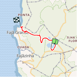
Tocht Stappen van 7,3 km beschikbaar op Azoren, Onbekend, Fajã Grande. Deze tocht wordt voorgesteld door Noiraude.
Beschrijving
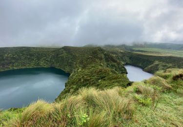
Ce parcours débute près du mirador des Lagoas Negra et Comprida.
Commencez par suivre le sentier qui contourne la lagoa Comprida par la droite, où domine la flore endémique, en particulier le sanguinho (Frangula azorica), le genévrier (Juniperus brevifolia) et les sphaignes (Sphagnum sp.). En arrivant à la route, vous pourrez voir en face la lagoa Seca.
Tournez à gauche sur l’asphalte et 50m plus loin, prenez le sentier sur la gauche qui vous mènera à la lagoa Branca. Il est souvent inondé et boueux, ce pourquoi il convient de faire attention. Un peu plus loin, vous arriverez à un chemin de graviers. Prenez-le sur la droite et au bout d’1,5 km environ, tournez à gauche. Un peu plus loin, franchissez la barrière et continuez dans le pré, en longeant le mur à droite.
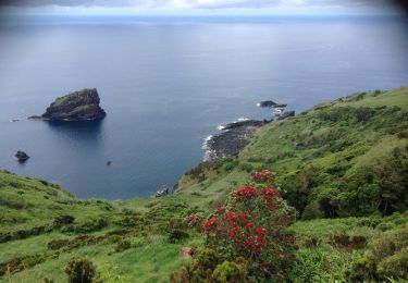
700m plus loin, vous verrez un escalier de pierre qui vous mènera à un autre pâturage, dont la vue donne sur Fajã Grande. Suivez-en la clôture et quelques mètres plus loin, vous trouverez un escalier sur la gauche, à la pente assez forte, qui vous mènera à Fajã Grande.
En arrivant à la route, prenez à droite et descendez environ 500m jusqu’à l’indication de Poço do Bacalhau (280m)
POI's
Plaatsbepaling
Opmerkingen
Wandeltochten in de omgeving
![Tocht Te voet Fajã Grande - Miradouro das Lagoas - Poço do Bacalhau - Photo](https://media.geolcdn.com/t/375/260/4de02320-9653-447c-b6d7-07a1568fcb70.jpeg&format=jpg&maxdim=2)
![Te voet Te voet](https://static1.geolcdn.com/sitytour/trail-icons/100.png)
Te voet
![](/images/other/stat-length.png)
![](https://static1.geolcdn.com/siteimages/upload/files/16400158638029165_repeat_loop_refresh_sync_direction_icon.png)
![Tocht Te voet Fajãzinha - Lajedo - Fajã Grande - Photo](https://media.geolcdn.com/t/375/260/6fe28863-b0c4-4f86-9505-2fc2955821c1.jpeg&format=jpg&maxdim=2)
![Te voet Te voet](https://static1.geolcdn.com/sitytour/trail-icons/100.png)
Te voet
![](/images/other/stat-length.png)
![](https://static1.geolcdn.com/siteimages/upload/files/16400158638029165_repeat_loop_refresh_sync_direction_icon.png)
![Tocht Stappen Fajã Grande - Le tour des lacs de cratère à Flores - Photo](https://media.geolcdn.com/t/375/260/39a9fcac-170d-4b96-a355-fadd4f01dbc9.jpeg&format=jpg&maxdim=2)
![Stappen Stappen](https://static1.geolcdn.com/sitytour/trail-icons/101.png)
Stappen
![](/images/other/stat-length.png)
![](https://static1.geolcdn.com/siteimages/upload/files/16400158638029165_repeat_loop_refresh_sync_direction_icon.png)
![Tocht Andere activiteiten Mosteiro - Mosteiros Lajedo - Photo](https://media.geolcdn.com/t/375/260/ext.jpg?maxdim=2&url=https%3A%2F%2Fservices.sitytrail.com%2FGeolivesWS%2FDownloadMedia.ashx%3FTrailID%3D592658%26Media%3D20160703140657.jpg)
![Andere activiteiten Andere activiteiten](https://static1.geolcdn.com/sitytour/trail-icons/900.png)
Andere activiteiten
![](/images/other/stat-length.png)
![](https://static1.geolcdn.com/siteimages/upload/files/16400158638029165_repeat_loop_refresh_sync_direction_icon.png)